The name of the Abbey and village – Talyllychau – both derive from the lakes – the ‘Head of the lakes’. Evidence from fossil pollen in Talley Lakes shows that 3000 years ago there was considerable clearance of woodland. Evidence of Iron Age occupation is thinly distributed with no hillforts north of the upper Cothi valley and a still heavily forested area and mainly pastoral economy.
Some hazel reappears in the Roman period, with known military activity in the area – a fort at Pumsaint, gold mines at Dolaucothi and possibly silver-lead mines at Rhandirmwyn. Roman rule was replaced in the 5th and 6th centuries by small Welsh ‘kingdoms’, when woodland appears to have recolonised.
The next distinct change marks the steady clearance of woodland and increasing cultivation, reflecting the 12th century foundation of Talley Abbey and its methods of farming. The Lord Rhys generously endowed his new abbey with lands, run like big estate farms. The upland granges around Talley concentrated on sheep and cattle, and the lowland on cereals.
The upland part of the walk gives a good experience of landscape change and the effects on large upland commons. Some of the 18th/19th century enclosure boundaries are now gone, demonstrating the ongoing changes in our rural landscapes. Some of the walks follow drovers’ roads, used until the first half of the 19th century in North Carmarthenshire.
In the twentieth century one of the biggest changes was the decline of the landed gentry and their country houses. The history of Talley is dominated by the Williams of Edwinsford from the Middle Ages through to the 1970s. Today’s visitors can act as landscape detectives looking for traces of ‘estate’ landscapes – the tree lined carriage drives, lodges, gates, etc.
Why Walk?
The area is worth visiting if only to admire the remains of the Abbey. The addition of the walk takes you high onto the surrounding hillside with panoramic views across this beautiful unspoilt part of Carmarthenshire.
How Long?
Approx. 4 KM (2.5 miles)
How Hard?
There are quite steep ascents and descents on route that some walkers may find a challenge.
Parking - There is limited parking outside of the Abbey walls but an NRW car park is normally open in the woodland opposite.
Facilities - A public toilet but there are no cafes or shops, however the Abbey ruins are a perfect picnic spot.
Starting Point – Talley Abbey
Points of interest
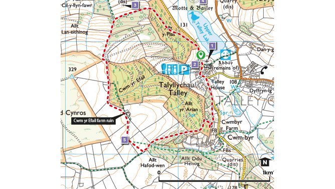
1. Talley and the Abbey.
Roman rule was replaced in the 5th and 6th centuries by small Welsh ‘kingdoms’ and the area became increasingly cultivated. The Abbey was founded in the 1180’s by the Lord Rhys ap Gruffydd of Deheubarth who also donated a generous amount of land. Henry VIII closed the Abbey, which had become impoverished and neglected in the later Middle Ages and confiscated its estates. Under the patronage of the Williamses of Edwinsford, a new parish church was built in 1773, using Abbey stone
2. Natural Resources Wales - Car park and Walks.
In addition to the walk highlighted here NRW have an open access policy in their woodlands which allow for several other possible walks in the area.
3. Pen y Garreg Lead Mine
Processing buildings, a main shaft and other ‘levels’ of the former Pen-y-garreg Lead Mine, worked until 1892. Below the road northwards from the Abbey was an air shaft, and in the woodland an adit driven to reach the mineral-bearing ‘lode’.
4. Talley Lakes and Castle Mound
Talley’s two lakes are havens for wildlife, formed at the end of the Ice Age by debris left by the retreating ice sheets. The Lower Lake is a Nature Reserve managed by the West Wales Wildlife Trust, home to Tufted Ducks, Cormorants and Great Crested Grebes. The tree-covered mound between the lakes is that of a motte and bailey castle, possibly a native Welsh fortification built on wooden piles. The ‘canal’ between the two lakes is the work of the Edwinsford family.
5. Mynydd Cynros - Commons and Enclosure
This area was Talley Common, providing common pasture for the freeholders of the manor. An Act of Parliament of 1817 authorised enclosure. The straight lines and regular pattern of boundaries shows the pattern of enclosure very clearly. Cwm-yr-Efail Farm was probably built at the same time.
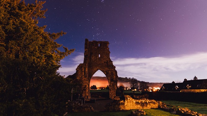
Talley Abbey
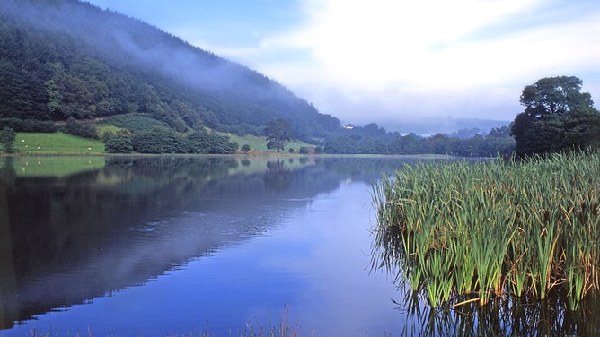
Talley lakes