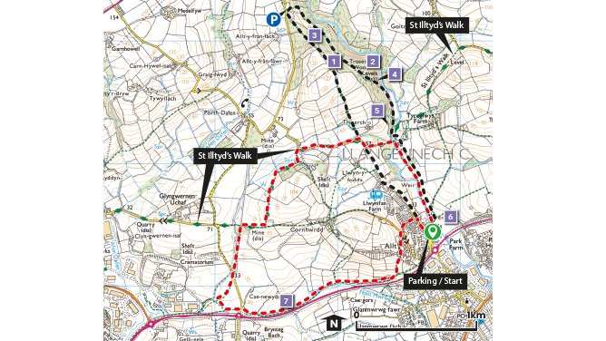
The two circular walks are both approximately 5 Km (3.1miles) long. Combining the two walks makes it approx.7.5 Km (4.7miles) long.
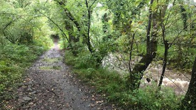
The landscape provides for very varied walking, alongside the river Morlais, into woodlands and across open fields, each has its own special character.
Llangennech really does have something to suit everyone. As well as the two routes ,there are also many permissive trails to explore in Troserch woods.
The rolling landscape of the area is split from north to south by the Afon Morlais.
The area still holds signs of its coal mining past, but the spoil heaps have long since greened over and there remains barely a trace of its industrial heritage. Byways, green lanes and footpaths now reach out into the meadows, pastures and woodland, inviting walkers to enjoy this picturesque agricultural area on the edge of Carmarthenshire.
Both St Illydyds Walk, and The Heart of Wales Line Trail follow sections of the Llangennech walks.
Why Walk?
The landscape provides for very varied walking, alongside the river Morlais, into woodlands and across open fields, each has its own special character.
How long?
The two circular walks are both approximately 5 Km (3.1M) long. Combining the two walks makes it approx.7.5 Km (4.7M) long.
How hard?
Much of the walking is over moderately flat ground but there are some short steeper sections, and some paths can be muddy in places after rain.
Public transport – The nearest train station is Hendy station which is approx. 2km south of the walks. There are also good bus links from Llanelli to Llangennech.
Refreshments – Shops and other amenities in Llangennech town
Parking/Starting point – There is ample parking along the roadside, however there is a designated car park at the northernmost entrance to Troserch woods.
Points of interest
1. Troserch Woodlands Society was set up to buy this ancient woodland in 2006 with their stated aims of “protecting the pathways, encouraging wildlife, introducing native species of trees and plants whilst also making the woods an enjoyable place to visit”. The woodland is a mix of broadleaf and coniferous trees with markedly different ground flora.
2. The evergreen trees in this part of the wood cast deep shade year-round favouring plants that tolerate damp shady places, such as Ferns, Mosses and Fungi. Scaley Male Ferns are abundant and easily identified by the many brown scales running along the length of the stem.
3. Broadleaf woodlands let light through the canopy before the leaves grow back in spring and summer allowing early flowering plants such as Bluebells, Wood Anemone, and Lesser Celandines to bloom.
4. Small shafts and tips of early coal mining in the area are dotted around this part of the wood they were a part of the old Goitre-wen colliery.
5. The ruins of Troserch Corn Mill and its leat can see be seen next to the path, this was one of several corn and woollen mills that once serviced the area.
6. This area now farmland was once a part of Llangennech Park. Dressed stone walls and a copse of trees hint at a time gone by.
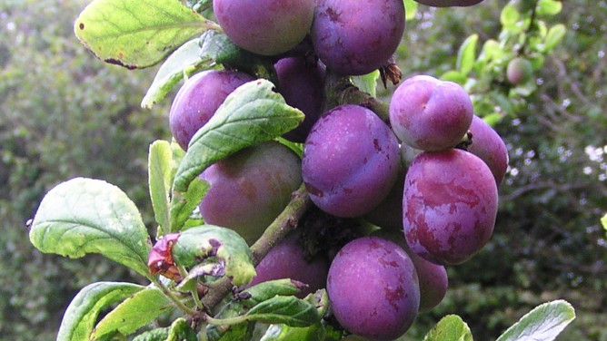
7. Bullace, (a type of plum) can be found, along with blackberries on this section of the route. Their fruits can be enjoyed when out walking in late summer and early autumn.