Big Wilderness Adventure
Llyn Brianne and the roads that lead to and from it are some of the most spectacular and rewarding roads you can ride anywhere in the world.
Highlights
Llyn Brianne – A challenging climb up to the reservoir followed by an incredible road around the perimeter with fantastic views.
Upper Towy Valley – Beautiful valley with quiet roads and scenic views from the start up to Llyn Brianne.
Soar Y Mynydd – The most remote chapel in Wales with fantastic roads to and from it.
Start: Llandovery
Total Distance: 105km/65 miles
Total Elevation: 1700m/5500ft
Difficulty Rating: 7/10
Estimated Time: 4 to 7 hours
Starting from Llandovery car park head out on the A40 towards Llandeilo, turning right onto the A483 before the level crossing and after 500 metres turn left, signposted Rhandirmwyn and Llyn Brianne.
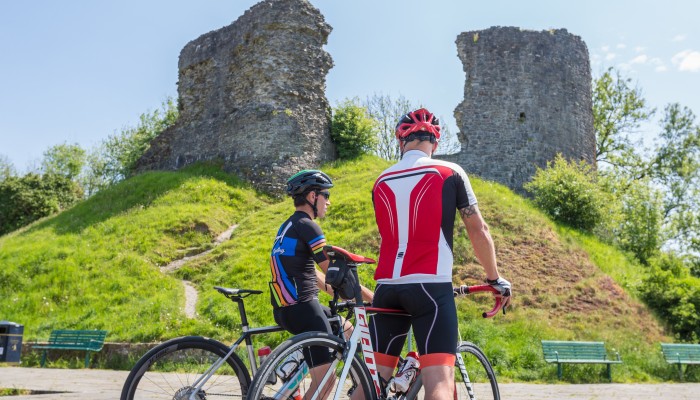
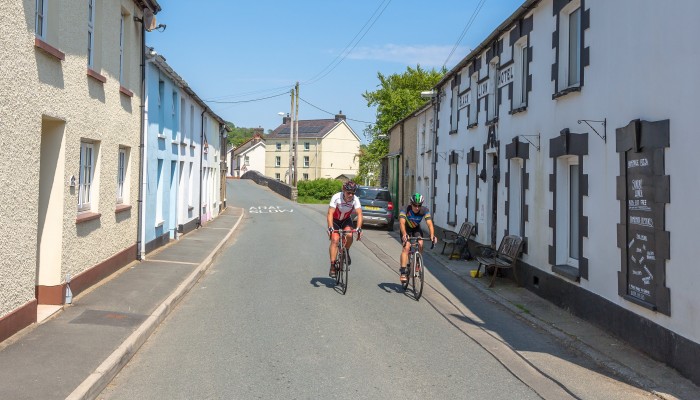
Llandovery is a market town with history dating back to medieval times with a castle standing tall within the town centre and it is also a popular Drovers stopping point, which is the nickname of the rugby club in the town. The town sits on junction of several rivers, including the Bran, Gwydderig and Towy and our loop starts by following the river Towy upstream, towards its source.
It is worth noting that the route takes in a large portion of wild, uninhabited terrain so it is worth taking what you think you will need with you and not relying on shops around the route. Llandovery has several fantastic cafes and restaurants, so fuelling up before leaving is easy to do with good food and coffee easy to find and several bike friendly places.
Llandovery is surrounded by countryside it is just a matter of minutes after starting that we exit the urban area and join quiet country roads. The route gives a good chance to warm up with no steep hills early on, instead a very gradual rise as the road follows the path of the Towy upstream. After 7 kilometres the first hill starts, but it still is not too severe and reaching the village of Rhandirmwyn is reasonably easy.
Follow the minor road through Rhandirmwyn and continue all around Llyn Brianne reservoir. After 30km bear left, continuing to follow the road to Tregaron, 48km into the route.
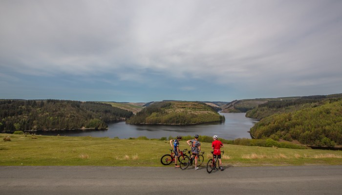
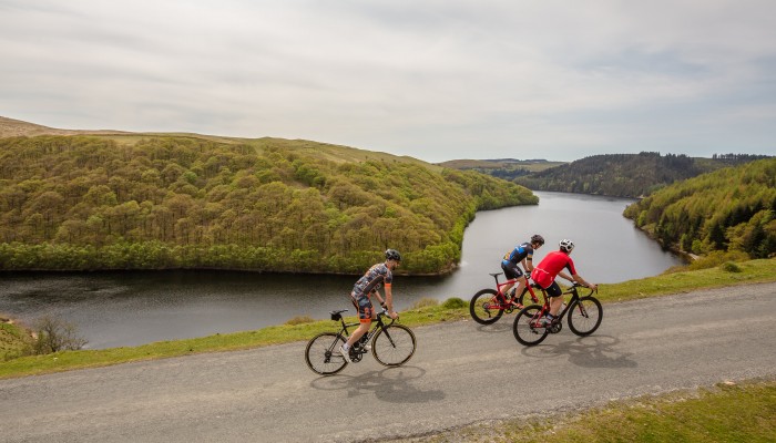
A few kilometres after passing through the village the fun begins! As the road starts to point upwards as the climbing continues for several kilometres with towering steep sides of the Towy valley on each side of you and passing local landmarks including the Dinas RSPB nature reserve which is also the supposed hideout location of Welsh folklore character, Twm Siȏn Cati, known as the Welsh of Robin Hood. As you pass Dinas the road continues to climb and while our route misses the dam wall of Llyn Brianne, it is only a few hundred meters diversion. A left turn as the road levels off takes you to the top of the dam wall, which is the tallest in the UK at 91 metres in height.
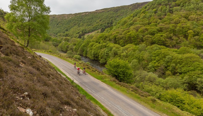
Back onto the route the road follows the reservoir around the edge, constantly changing in elevation with incredible views and sweeping descends around every corner. With recent deforestation in some areas it only adds to help improve the views as you ride around and there are several spots as you ride that are worth stopping quickly to admire the view. The reservoir was created in the 1960s and a few houses were abandoned and submerged to allow its creation. During very hot and dry summers one of the houses can be visible and it has even been possible to walk to it, but this has only happened a few times since the reservoir was created several decades ago.
As the reservoir ends our route forks left and across a small white bridge over the Towy at the point the river becomes a reservoir and climbs up and over to another, almost hidden landmark of Soar y Mynydd chapel. In the direction of travel it is easy to miss as it passes on the left at the bottom of a fast descent. It is reputedly the most remote chapel in Wales and given it is 8 miles from the nearest village or town it is easy to believe.
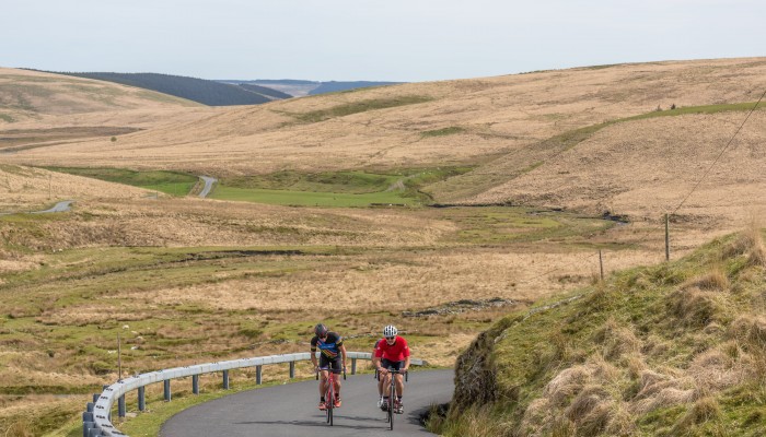
As the route continues heading north the surroundings feel even more remote, skirting the Cambrian mountains which is known as the 'Desert of Wales' and while there is no sand the landscape is very barren with barely a house, farm or car in sight but with the emptiness comes an incredible beauty that is seen nowhere else short of the Scottish border.
Starting from Llandovery car park head out on the A40 towards Llandeilo, turning right onto the A483 before the level crossing and after 500 metres turn left, signposted Rhandirmwyn and Llyn Brianne.
Llandovery is a market town with history dating back to medieval times with a castle standing tall within the town centre and it is also a popular Drovers stopping point, which is the nickname of the rugby club in the town. The town sits on junction of several rivers, including the Bran, Gwydderig and Towy and our loop starts by following the river Towy upstream, towards its source.
It is worth noting that the route takes in a large portion of wild, uninhabited terrain so it is worth taking what you think you will need with you and not relying on shops around the route. Llandovery has several fantastic cafes and restaurants, so fuelling up before leaving is easy to do with good food and coffee easy to find and several bike friendly places.
Llandovery is surrounded by countryside it is just a matter of minutes after starting that we exit the urban area and join quiet country roads. The route gives a good chance to warm up with no steep hills early on, instead a very gradual rise as the road follows the path of the Towy upstream. After 7 kilometres the first hill starts, but it still is not too severe and reaching the village of Rhandirmwyn is reasonably easy.
Continue to Llanybydder, turning left at a cenotaph onto the B4337 (Heol Llansawel). Follow the road to Llansawel, turning left on a downhill signposted Llanwrda. Follow the road, heading straight ahead at a staggered cross-roads.
Turn right onto the A482 at the top of a hill, follow for 2km, then turn left, signposted Porthyrhyd. Continue through the village and follow signs for Llandovery.
The border for Carmarthenshire lies on the Teifi for this section of the river while Llanybydder almost dissected with as the river flows through the town. With a few shops and most amenities it could be a useful place to stop and is the last major town with a shop before the finish. As we leave the town the road gradually climbs once again and slowly the gradient increases. Not known as any name in particular the climb, at almost 5 kilometres and with a reasonable height difference it is no walk in the park. The descent is steeper than the climb, so many will perhaps be relieved not to be climbing up from that side at least as the roads drops on a twisting descent to the village of Rhydcymerau.
The tree lined road to the village of Llansawel is fantastic and especially on a warm day, giving some relief from what has been a very open route to this point. As we drop into Llansawel it would be easy to miss the junction which is on a fast descent. Shortly after passing through the village and one final long climb takes us up to the A482 and joins one of the only sections of A-road for the entire route, all 2 kilometres of it and all downhill before pealing off and heading towards Porthyrhyd.
The final section back to Llandovery is one to relish, with a few small kickers to start and an incredible glimpse of the Bannau Sir Gar, a mountain and the highest point in Carmarthenshire in the distance should the weather be on side. One final and fantastic descent starts after Siloh and drops through several flowing bends just a few flat miles from the outskirts of Llandovery. With several fantastic cafes, most of which are bike friendly there are several options to sit down and reminisce on what will have been an incredible route.
Starting from Llandovery car park head out on the A40 towards Llandeilo, turning right onto the A483 before the level crossing and after 500 metres turn left, signposted Rhandirmwyn and Llyn Brianne.
Llandovery is a market town with history dating back to medieval times with a castle standing tall within the town centre and it is also a popular Drovers stopping point, which is the nickname of the rugby club in the town. The town sits on junction of several rivers, including the Bran, Gwydderig and Towy and our loop starts by following the river Towy upstream, towards its source.
It is worth noting that the route takes in a large portion of wild, uninhabited terrain so it is worth taking what you think you will need with you and not relying on shops around the route. Llandovery has several fantastic cafes and restaurants, so fuelling up before leaving is easy to do with good food and coffee easy to find and several bike friendly places.
Llandovery is surrounded by countryside it is just a matter of minutes after starting that we exit the urban area and join quiet country roads. The route gives a good chance to warm up with no steep hills early on, instead a very gradual rise as the road follows the path of the Towy upstream. After 7 kilometres the first hill starts, but it still is not too severe and reaching the village of Rhandirmwyn is reasonably easy.
Useful info
Beiciau Hobbs Bikes – Bike Shop, Carmarthen